Diascund Reservoir Resource Page

Information gathered from Virginia Game and Inland Fisheries

This 1,110-acre water supply reservoir is situated along the New Kent and James City County line. The principle species are largemouth bass, bluegill, chain pickerel, redear sunfish, black crappie, yellow perch, and white perch. Carp, bowfin, and longnose gar provide alternative quarry. Gizzard shad and blueback herring are the main forage species. The latest sampling showed the bass population to be in very good condition in terms of abundance and quality. The proportion of large bass (greater than 20″) in the sample was high. Two of the five sites sampled were in the Diascund Creek branch of the reservoir, upstream of the Route 627 road bridge. These turned out to be the most productive for bass at the time of sampling, especially amongst the lily beds in the spring. By summer larger bass were found associated with the logs and tree trunks in about 10 feet of water. The bluegill population was also in good shape. The number of fish in the 7-8 inch size group had increased significantly.

In 2001, this reservoir placed second in the state for the number of chain pickerel trophies reported. Large chain pickerel are still present in the reservoir and offer anglers exciting thrills. Our sampling in 2002 documented a 13-lb. bowfin, which if caught by rod and reel at the time, would have qualified as a state record. Facilities include a boat ramp and courtesy pier. Bank fishing is allowed in designated areas adjacent to the boat ramp. Electric trolling motors are the only motors permitted. The hours of operation are from one hour before sunrise to one hour after sunset.

The lake is located east of Providence Forge on Route 603 off Route 60 near Lanexa. For added information call the VDGIF at 757-253-4172.

Fishing

This fishery continues to perform well for a number of species. The results of the latest survey show the largemouth bass population to be in good shape (as indicated by structural indices, relative weight and physical examination). The largest bass picked up during our survey was almost 23 inches in length and weighed almost 6 lbs.

Bluegill were abundant (especially juveniles) and ranged up to 8 inches in length. Through our sampling efforts over the years we have found that the large impoundments of the middle and lower peninsula rarely produce bluegill much bigger than this. The overall status of the population was fair. The redear sunfish population has improved over the last three survey periods. The increase in electrofishing catch rates for fish over 8 inches in length and the general status of the population structure bodes well for future angling opportunities.

The black crappie and yellow perch populations are also developing well. Smaller fish dominated the sample, but there was a shift toward a better proportion of larger fish. The largest black crappie was 13 inches and the yellow perch were up to 11 inches. The chain pickerel population has been relatively stable, yielding trophy fish citations on a regular basis.

Anglers should not overlook the exciting fishing opportunities that exist for bowfin and longnose gar. Although the numbers of bowfin are not as high as nearby Chickahominy Lake, there are some large fish that inhabit the reservoir. The 2002 electrofishing sample collected two citation-sized bowfin that weighed 12.8 and 11.7 pounds.

Claytor Lake Resource Page

Information gathered from Virginia Game and Inland Fisheries

Claytor Lake, a 4,475-acre impoundment of the New River, stretches northeastward across the Pulaski County countryside for 21 miles. Possible catches from Claytor Lake range from bass to carp. Smallmouth, largemouth, and spotted bass (collectively called “black bass”) are the “bread and butter” fishes of this lake. About 58 percent of the anglers at Claytor Lake fish for “black bass.” The three black bass species in Claytor Lake are regulated by a 12-inch minimum size limit and anglers may harvest five per day (all three species combined). Anglers are encouraged to practice catch-and-release of trophy-size bass from the lake. Claytor’s steep and rocky shorelines make it particularly good for smallmouth bass. In 2001, Claytor Lake produced 15 smallmouth bass certificates (more than five pounds or over 20 inches).

Claytor Lake holds fewer largemouth bass than other Virginia lakes, and they grow slowly in this mountain reservoir. Claytor Lake’s largemouth bass populations appear to be increasing. In 1990, largemouth bass made up about 10 percent of the black bass according to electrofishing catch results by fisheries biologists studying the lake. Largemouth bass increased to about 30 percent of the black bass electrofishing catch by 1998. Anglers can find this species in coves throughout the lake, but they are most abundant in Peak Creek. The Claytor Lake record for largemouth bass was a 14- pound, 6-ounce giant caught in June 1991.

Spotted bass in Claytor are generally smaller than the other black basses. They rarely reach 2 pounds in size. In fact, most anglers that think they are catching small largemouth bass are probably catching small spotted bass, particularly in the upper lake area (above Lighthouse Bridge) where spotted bass are more numerous.

Anglers fishing for black bass in the lake can use information collected on bass food habits during a recent study at Claytor Lake to select lures and techniques for these species. Smallmouth bass and spotted bass have very similar diets, with both relying mostly on crayfish. Techniques and lures that mimic crayfish are most likely to be successful in producing catches of these fish. Both of these bass species eat a lot of bluegill as well as some alewife and gizzard shad, so they may also hit lures that imitate fish. Largemouth bass diets are quite different than smallmouth and spotted bass diets, which may be one reason they are doing so well in the lake. Largemouth bass eat bluegill, alewife, gizzard shad, and crayfish, depending on the season of the year and whether these prey are abundant in a given year. Lures that imitate fish are the best choice for largemouth bass, but they may also hit crayfish imitations.

Fish

The Department maintains the striped bass population in Claytor Lake through annual stocking. The Department experimented with increased stocking rates for striped bass in Claytor Lake in 1998, 2001, and 2002. Doubling the stocking rate in 1998 and 2001, combined with good spawns of alewife and gizzard shad, has resulted in two prominent year classes of stripers in the lake. The 1998 stripers are now running from 28 to 32 inches in length and they weigh between seven and 12 pounds. The 2001 stripers are in the 15 to 18 inch range, so they will reach harvestable size in 2003. Recent sampling indicates that the some of the 2000 stripers will be represented in future catches at the lake. It is still too early to tell whether the 2002 stripers will produce similar numbers of adult fish to those from the 1998 and 2001 stockings.

Claytor Lake produced 15 certificate (more than 20 pounds or over 37 inches) stripers in 2001. At least one striper over thirty pounds in size is caught each year in this lake. Stripers can be caught year-round, although most anglers have their greatest success from late September through May. Water temperatures at or below 70 degrees seem to produce the best fishing.

Recent striper diet studies at Claytor Lake showed that stripers rely mostly on alewife and gizzard shad. Therefore, it is no surprise that Claytor Lake anglers experience the best success using these species as bait. Gizzard shad and alewives are most easily caught using a cast net near the back ends of coves. Peak Creek is a great place for finding bait, but don’t overlook smaller coves in the lake. Many stripers are taken with topwater baits (Redfins, Rapalas, etc.) and bucktails in the spring and fall. Fish points and flats adjacent to deep water for best topwater action. Trolling bucktails in 20-60 feet of water can produce good catches.

During the summer and early fall months stripers primarily “hole up” in the middle and lower lake areas close to the lake’s thermocline (30-40 feet deep), where they find suitable temperature and oxygen levels. When the lake begins to cool in October, stripers begin chasing shad and alewife schools around the lake and are more difficult to locate. If you are lucky enough to see them chasing shad at the surface, you can catch them on top water lures. In winter months, look for stripers in the middle and upper lake areas, from the mouth of Peak Creek up to the Lighthouse Bridge. At this time of year, a good depth finder is the single most important piece of equipment needed to locate fish, because stripers are likely to be located in 40-60 feet of water. Find the bait schools and you are likely to find the stripers nearby.

Hybrid striped bass were introduced to Claytor in 1992 and are stocked each year. Many of the fish from the earliest stockings are 8-12 pounds today! These striped bass hybrids are a hard fighting fish that are good to eat! Since they can tolerate higher water temperatures, hybrids often chase schools of shad at the lake’s surface at night in the summer months. Most of the time, hybrids live at similar depths and locations as the stripers in the lake. Their diet is very similar to stripers, so they can be caught using the same techniques.

White bass are found in Claytor Lake, but their numbers are down from historic levels. The best opportunity to catch white bass from the lake is during April and May when they run upstream to Allisonia, where the New River flows into Claytor Lake.

Anglers should keep in mind that the harvest of stripers and hybrids is limited to 4 fish per day (the two species combined), all of which must be longer than 20 inches. White bass are regulated by a creel limit of five per day, with no size limit. Anglers should study the differences between these fish carefully. Helpful identification information is available in the Department’s recent publication, “The Angler’s Guide to Virginia Freshwater Sportfish,” which is available from Department offices statewide.

Walleye are still occasionally caught from the lake, but their numbers have dropped off since stocking was discontinued in 1996. Anglers have recently been catching yellow perch in the one-pound range. Black crappie caught from the lake typically average a little less than a pound. According to the Department’s creel survey in 1998, many anglers take home a limit of 25 bluegill that average 0.5-pound each. Flathead and channel catfish (up to 20 pounds) can also be caught from the lake. With catches of 20-30 pound carp possible, anglers from as far away as England come to fish for them at Claytor.

Claytor Lake State Park

Claytor Lake State Park, located on the north side of the lake, provides 497 acres of park with camping, cabins, picnic areas, and a swimming beach, as well as a marina. For more information on the park, call 540-643-2500.

Boat Access

Boat access to the lake is available for a small fee at private ramps at Claytor Lake State Park, Lighthouse Bridge, and at Conrad Brothers and Rockhouse Marinas on the Peak Creek arm of the lake. The Department maintains no-fee ramps at Allisonia (in the upper lake area) and near the entrance to the state park (Dublin Ramp). Harry’s Point boat ramp, a no-fee ramp located in the mid-lake area within Pulaski County’s Harry DeHaven Park, has a double ramp and courtesy piers. Harry’s Point also has a handicapped-accessible fishing pier, where many of the lake’s species can be caught throughout the year. During the fall and winter months, anglers are likely to catch striped bass and hybrid striped bass swimming near the pier.

Directions

The easiest way to get to Harry’s Point from I-81 is to take the Route 605 exit (near the south end of Radford), and then follow the brown trailblazer signs to Harry DeHaven Park. From the I-81 exit ramp, take Route 605 (Little River Dam Road). Follow Route 605 until you reach Route 663 (Owens Road), go right on 663, then look for signs marking the park when you get near the lake.

If you have fishing questions about Claytor Lake, call the VDGIF Blacksburg office at 540- 951-7923.
Chickahominy Lake and River Resource Page

Information gathered from Virginia Game and Inland Fisheries

Chickahominy Lake

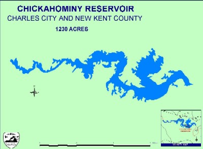
This is a 1230-acre water supply reservoir located along the New Kent-Charles City county line. The low-head dam of this reservoir (known locally as Walkers Dam) was completed in 1943 and incorporates twin Denil fish ladders to allow for the passage of anadromous fish such as blueback herring and striped bass. Surveys in 1989, 1990 and 1992 indicted that river herring were passing through the ladder in tremendous numbers and spawning both within and upstream of the reservoir. There is a manually operated boat lock at the dam, which allows boat traffic to move between the reservoir and river.

This cypress-laden lake provides spectacular scenery, and is great for bird watching. In addition, it just happens to be one of the best all round fisheries in Virginia. The cypress trees, water lilies and submerged aquatic vegetation (SAV) provide excellent habitats for aquatic organisms and are undoubtedly one of the reasons for the consistently good fishing at this lake over the years.

Chickahominy River

With broad expanses of open marshes, cypress trees dotting much of its shoreline, and a diversity of fish species choose from, the Chickahominy River provides the angler with tidal river fishing at its finest.

This river has supported a nationally recognized largemouth bass fishery for many decades. Although in recent years bass fishing was off somewhat, the largemouth population in the tidal Chickahominy has improved.

Blue catfish are the most abundant catfish occurring in the tidal Chickahominy, and can be caught throughout the year in the Chick and its tributaries. Although the Chickahominy doesn’t yield as many citation-size blue catfish as the tidal James, each year the Chick ranks as one of Virginia’s top blue catfish waters and typically provides anglers with abundant catches.

The river herring run continues to draw a number of anglers to the tidal Chickahominy at Walkers Dam each spring. During the peak of the run, armed with bare gold hooks or small spoons, anglers can land an abundance of these unique fish. Anglers are reminded that all river herring caught above Walker’s Dam must be released.

Striped bass occur throughout the tidal Chickahominy, and are available to anglers during both the spring and fall seasons.

In the tidal Chickahominy River, regulations setting season and creel limits for American shad, Hickory shad, river herring, and striped bass are set by the Virginia Marine Resources Commission (VMRC). For information regarding these regulations contact VMRC in Newport News at 1-800-541-4646 or on the web at: http://www.mrc.state.va.us/swrecfishingrules.htm

The tidal Chickahominy River can be accessed at the following public landings: Chickahominy Riverfront Park (formerly Powhatan Resort) 757-258-5020; the Chickahominy Wildlife Management Area ramp on Morris Creek; and Brickyard Landing west of Toano, off Route 610. Private (fee) ramps include: Rock-a-Hock Campground 804-966-2759; Riverside Camp 804-966-5536; Colonial Harbor 804-966-5523; and River’s Rest 804-829-2753. Walker’s Dam, accessed through Rock-a-Hock Campground, is located off U.S. Route 60 on Route 649, west of Lanexa

Fishing

The largemouth bass fishing at this lake has been consistently good over many years. The results of the 2003 survey show that the largemouth bass population is in good shape overall. Structural indices were in line with that expected for a balanced fishery. Physical examination of the fish showed them to be in good condition and this was supported by an index of relative weight. The largest fish caught in our sample was 21 inches in length and weighed almost 5 lbs. The data compares favorably with the results of the previous survey conducted in 2000. The main difference being a slight reduction in the proportion of larger fish (greater than 12 inches in length) and an increase in the number of younger fish (less than 8 inches in length).

Bluegill were very abundant, especially those under 6 inches in length. Having said that, the catch rate (number of fish caught per sampling hour) for larger fish (6 to 8 inches in length) was relatively good and considerably higher than that recorded during the 2000 survey. Our sampling indicates that the redear sunfish population is also developing well.

Our survey indicates that the black crappie population is in decent shape, with the largest fish in our sample topping out at 14 inches. The overall population structure was similar to that recorded in the 2000 survey, but the condition of the fish was better.

Angling enthusiasts will enjoy the fact that this is a diverse fishery. Chain pickerel, bowfin, gar and carp are present in sufficient numbers and size to provide alternative quarry.

For some time now, the reservoir also has provided a popular catch-and-release fishery for anadromous (sea run) striped bass that have passed through the fish ladder at Walker’s Dam (see the Regulations section for more information).

Maps

Outline

Outline

Maps can also be purchased from:

GMCO Maps

Additional Information

Woods and Water Magazine Article on Fishing in Chick Lake

Lake Chesdin Resource Page

Information gathered from Virginia Game and Inland Fisheries

Lake Chesdin is a 3,100-acre water supply reservoir on the Chesterfield-Dinwiddie County line administered by the Appomattox River Water Authority. Chesdin is a very productive lake that offers excellent largemouth bass fishing, good crappie fishing (both black and white) in spring and fall, and a great channel catfish fishery. For experimental reasons, walleye stocking has been reduced in recent years. Even so, numerous walleye up to 7 pounds were collected in gill net samples in 2004. As a result, the Department has decided to increase walleye stocking beginning in 2005. Striped bass have been stocked for many years, but none were harvested by anglers who were interviewed for the creel survey in 2003, and very few have been collected in gill net samples. Consequently, striped bass stocking is being terminated.
Due to the opening of a fish lift in Brasfield Dam (AKA Lake Chesdin Dam) during spring, 2005, anadromous fish will have access to the upper Appomattox River for spawning for the first time in many years. Although relatively few shad and herring are expected to use the lift during this first year of operation, a good spring fishery may develop in the upper river if spawning runs improve over time.

The public boat ramp and handicap-accessible fishing pier are open 24 hours a day. There are three private marinas with boat ramps, rental boats, bait, tackle, camping, and picnicking.

Lake Chesdin Maps

Maps for Lake Chesdin can be purchased from the following companies

GMCO Maps

Fishing Hot Spots

Buggs Island / Kerr Reservoir Resource Page

Information gathered from the Virginia Game and Inland Fisheries

Buggs Island Lake is about 48,900 acres at full pool and has one of the best largemouth bass fisheries in the country. Surveys on largemouth bass indicate high rates of reproduction and growth. Largemouth bass in the 2-4 pound range are typical, however, trophy bass greater than eight pounds are rare. The best fishing is on the upper end of the lake and the lower end creek arms. Structure is important, and water levels affect how much structure is available. When water levels rise into the willow and sweet gum trees in spring, anglers should be sure to fish the backs of coves and the points. Channel catfish have traditionally been the most sought after catfish at Buggs Island; however, flathead and blue catfish have become popular as well.

The striped bass population is in fair condition and should be similar to the last couple of years. During spring, striped bass may be found in the upper end of the lake and in the river above the lake as fish travel upstream to spawn. During summer, habitat (combination of temperature and dissolved oxygen) forces striped bass to be found in the lower end of the lake (the dam to about Buoy 9 and in the mouth of Nutbush Creek). Fishing during the fall and winter is typically best from Goat Island to the Clarksville Bridge, although fish may be found throughout the lake. Striped bass caught during the summer suffer high mortality rates when released (approximately 75 percent). Therefore, we ask that anglers fishing during the summer retain their legal-size fish (20 inches or over) until they are done fishing for the day, or reach their limit (four/day) rather than continue to catch fish and cull smaller individuals. During the cooler months (October-May), striped bass are less stressed and do not suffer high catch-and-release mortality.

Buggs Island Lake is also one of Virginia’s best places to catch crappie. Fishing for crappie is typically best from February through April (pre-spawn and spawn); however, many anglers enjoy high catch rates year-round. Buffalo, Grassy, Bluestone, and Butcher Creeks are very productive for crappie. White bass used to be a real favorite at Buggs Island Lake. However, white bass populations are down in many Virginia reservoirs. White perch have recently become established in the lake and may have contributed to the decline of white bass. White perch are quickly becoming popular with anglers because they are abundant and can reach weights of nearly two pounds.

A portion of Buggs Island Lake is located in North Carolina, but Virginia fishing licenses are legal lake-wide. Disabled anglers are encouraged to visit the North Bend Park pier, which is designed especially for their needs. The end of the pier is located over 17 feet of water. Fish attractors, constructed of discarded Christmas trees, have been installed around the pier to enhance the fisheries habitat. Buggs Island Lake is located on the border of North Carolina, mainly in Mecklenburg County, and has numerous campgrounds, boat ramps, and recreation areas around it. For facilities information, call 804-738-6143 or visit the web at http://www.kerrlake.com/chamber. For information on lake levels, contact the U.S. Army Corps of Engineers at 804-738-6371.

Maps for Kerr Reservoir / Buggs Island

Maps can be purchased from the following companies.

GMCO Maps

Kingfisher Maps

Fishing Hot Spots

BC Fishing Maps

Briery Creek Resource Page

Information gathered from Virginia Game and Inland Fisheries

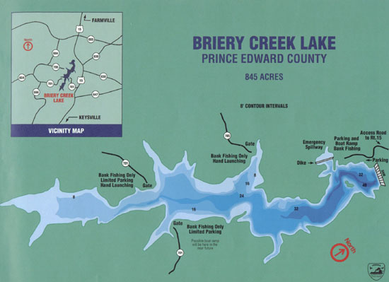
Briery Creek Lake is an 845-acre lake that is owned by the Department of Game and Inland Fisheries and is within the Briery Creek Wildlife Management Area in Prince Edward County. The dam was completed in 1986 and the lake was open to fishing in 1989. In 1986 and 1987 the lake was stocked with Florida strain largemouth bass, northern strain largemouth bass, bluegill, redear sunfish (also known as shellcrackers), channel catfish, and crappie. Timber in the floodplain was left standing or felled and drumchopped resulting in an abundance of fish habitat. Biologists hoped that the presence of Florida-strain bass and the complex habitat would produce a high quality largemouth bass fishery.

Initially, the largemouth bass regulation was an 18-inch minimum length and 2-fish/day creel limit. Early production of largemouth bass was excellent and in 1991, this regulation was changed to a 12 – 15 inch protected slot limit (5/day) to allow anglers to harvest the abundant smaller bass. Briery Creek Lake quickly began producing trophy largemouth bass and recognized as one of the state’s premier bass fisheries. To help protect this fishery, the regulation was changed to a 14 24 inch protected slot limit on January 1, 2001. The daily bag limit is still five bass per day, but only one may be longer than 24 inches.

Briery Creek Maps

Briery Depth Map

Briery Topo Map

More Maps

BC Fishing Maps

Articles on Briery

Article from Roanoke.com
Profile of a Trophy Fishery, Briery Creek Article on Southern Division of the American Fisheries Society website
Another Article from Roanoke.com
Old Virginia Pilot article on Briery
BASSMASTER.com (you will need to be registered for the site to see the article)

Fishing

Briery Creek Lake is one of the most important fisheries in the state and biologists certainly treat it as such. Not only are annual electrofishing samples conducted, but since 1999, creel surveys have been used to gather information as well (angler effort, catch, harvest and attitudes and opinions on the fishery). Spring creel surveys (March thru May) are an effective method for following trends in fishing, particularly for trophy bass (> 22 inches). The five years of creel data have given biologists the best information in evaluating this fishery and the trophy slot limit that went into effect on January 1, 2001.

Overall, angler catch rates (number/hour) have remained remarkably consistent since 1999 (about 4 fish/10 hours of fishing). This is a very good catch rate, particularly for the spring. What has varied is the catch rate of trophy bass. Since 1999, there have been three very good springs (1999, 2000, and 2002) and two average ones (2001 and 2003). The average springs were cool and wet in March and April, which likely had the big fish hanging in deeper water more than usual. Conversely, during the great springs, the weather was more normal and warmed up gradually so when the big fish came shallow to spawn, they stayed for a week or two. The big bass are most vulnerable when they are shallow. For one, anglers can see them. But perhaps just as important, there is a lot less water to cover when they are hanging in 3-5 feet as opposed to 12-18 feet. Finally, the warmer water has them feeding a little more aggressively. When the water temps are less than 60, the big largemouth at Briery are mainly caught on big minnows or jigs. The creel data shows a similar trend to the citation data but is much more reliable.

Therefore, the prediction for 2004 is watch the weather! The sooner the lake gets to 60 degrees, the sooner the fishing gets good. But it has to stay fairly constant. Anglers planning trips to Briery to target citation bass would be well served to shoot for the last week of March through April, but if it gets warm early, shoot for early-mid April. Anglers are welcome to call the Farmville office or Worshams grocery for more information.

Early results on the regulation change are very promising. Prior to the change, more than 100 citation largemouth bass were harvested per year. That has been reduced dramatically (which was needed). Will that result in more years like we had in the mid 90’s when Briery first emerged as the hot spot for trophy bass? Time will tell. What biologists do see happening with the new regulation is that we can ride the so-called good times for a much longer time than we could have under the former 12-15 inch slot limit. The new regulation has already changed the size structure of the fishery-we are collecting more 15-20 inch fish than ever before. It will be exciting to follow these fish and see if we can continue to recruit new trophies each year. But for now, Briery is still the best water in the state to chase 10 pound bass. But for those anglers who are not lucky enough to get a linker, they should have a blast with 2-4 pound fish.

James River Resource Page

Information about the James River gathered from the Virginia Games and Inland Fisheries Dept.

Upper James River

From the confluence of the Jackson and Cowpasture Rivers in Alleghany County, downstream to Richmond, the James River offers a wide range of angling opportunities and settings. Smallmouth bass are the dominant game species, but spotted and largemouth bass can also be caught. Smallmouth bass fishing should be good in 2002, with decent numbers of 11-14 inch fish. The numbers of smaller fish may be down a little from the past two years, but should be good enough to provide plenty of action.

Bass fishing will be good throughout the river. Both the mountain sections (upstream from Lynchburg) and the piedmont sections (between Lynchburg and Richmond) should have lots of fish. There is not a lot of difference in the fish populations from one spot to another, it is simply a matter of finding the particular locations where the fish are holding and using whatever bait or lure they might want that day.

Other species are also plentiful in the James River, including channel catfish, flathead catfish, and various sunfish species (redbreast, bluegill, and rock bass). Flathead catfish appear to be more numerous upstream from Lynchburg, and channel catfish are more numerous below Lynchburg. In the past few years, many large flathead catfish have been caught in the river, although numbers are lower this year. Sunfish numbers have been low over the past several years, but angler reports and Fisheries Division samples indicate that these species are rebounding. Sunfish should be more abundant in 2002, at least compared to the previous five years. Muskies are also annually stocked in the James. These fish are scarce, but some very large fish can be caught. Most of the muskies are found upstream from Lynchburg.

Overall, the James River offers an excellent fishing opportunity for whatever you might want. Canoeing is the best way to access the river, and a map showing access points is available from the VDGIF. Small boats (such as john boats) can also be used at some access points. Bank and wade fishing access is also available throughout the river.

From Scottsville throughout the fall line in the City of Richmond, anglers may find fewer bass than on many other sections of the river, but those caught tend to average much larger. An 11-14 inch slot limit regulation is in effect on smallmouth and largemouth bass. Anglers may keep small and large bass but must return all bass that are 11-14 inches in size. A good panfish population, predominately redbreast sunfish, also exists on the James River. Catfish are abundant, especially channel cats, and large flathead catfish can now be found in the fall line of the river in the City of Richmond. Access to the river is good, with many public boat ramps on the river from Scottsville to Richmond. The river is open to the public 24 hours a day.

Lower James River

The tidal James River and its tributaries support a nationally recognized largemouth bass fishery. The tidal James system was the site of previous Bass Master Classics and the FLW Tour Championship is scheduled to occur on the tidal James in September 2003. Upstream from Hopewell, fishing for largemouth is best in old river channels and abandoned gravel pits connected to the main stem. Downstream from Hopewell, largemouth fishing is most productive in larger tributary creeks, the main stem James River having very limited shoreline structure below Hopewell. The creeks between Hopewell and Hog Island provide excellent largemouth habitat, with abundant shoreline structure, such as old pier pilings and downed trees, adjacent to channel drop-offs as well as large expanses of vegetated tidal flats.

James River Maps

GMCO Maps for Virginia waters Probably the best available fishing map.

Navionics Nautical Charts and GPS Software Excellent Navigational charts as well as having chips available for use in GPS plotters.

James River Articles

Virginia Game and Fish Magazine James River Articles

Boat Launches

Upper James River Boat Launches

For the Upper James (above the fall line in Richmond) the Virginia Game and Inland Fisheries website has good maps that show the locations of all boat landings and ramps.  You can click the link below to get to that page
Virginia Game and Inland Fisheries Upper James Launch maps

Lower James River Boat Launches

For the Lower James boat launches are listed below:

Ancarrow Landing (public)

In Richmond off Route 5

Osbourne Landing (public)

Henrico County, 9680 Osbourne Turnpike

Directions

From 64 take the Laburnum Avenue Exit. You will want to take the Laburnum south exits. On Laburnum Avenue cross over Williamsburg Road, Charles City Road, Darbytown Road and Route 5/New Market Road. Laburnum becomes Burning Tree Road after crossing route 5. Take to the end and make a left on Osborne Turnpike. Go 3.5 miles and the entrance is on the right.

From 95 take exit 67 Rt. 895 towards the airport. Go over the bridge and through the toll plaza then take the first exit for Laburnum Avenue. Take the first left turn off the exit ramp. This will lead you to Burning Tree Road. Take to the end and make a left on Osborne Turnpike. Go 3.5 miles and the entrance is on the right.

From 295 take exit 22 Route 5 towards Williamsburg. Go to 2nd or third right turn Kingsland Road and make the right. Follow for several mile. Kingsland will run into Osbourne Turnpike and boat ramp will be right there on the left.

Dutch Gap (public)

Chesterfield County

Directions

From I-95 north or south, use Exit 61A, East on Rt. 10 to first stoplight, North on Rt. 732 to Rt. 615, Right on Rt. 615 follow signs to boat launch.

From 295 take the route 10 exit towards Chester. Go until just before you get to Rt. 95. Take a Right turn on Rt. 732 Stage Road and follow signs to the boat launch.

Deep Bottom (public)

Henrico County

Directions

From 95 take exit 67 Rt. 895 towards the airport. Go over the bridge and through the toll plaza then take the first exit for Laburnum Avenue. Go to the first traffic light and make a right on Route 5 towards Williamsburg. Take route 5 past where 295 crosses it then take the 2nd or third right turn for Kingsland Road then take your first left for Deep Bottom Road. Follow this to the boat launch.

From 295 take exit 22 Route 5 towards Williamsburg. Go to 2nd or third right turn Kingsland Road and make the right then take your first left for Deep Bottom Road. Follow this to the boat launch.

Hopewell City Marina (public with fees)

Hopewell City

Directions

From 95 use Exit 61A, East on Rt. 10. Follow Rt. 10 all the way to Hopewell. You will cross a long bridge over the Appomattox River. Immediately after crossing the bridge take the right turn exit. Follow to bottom of the hill and make a left and then the ramp is located on your right.

From 295 take the route 10 exit towards Hopewell. Follow Rt. 10 all the way to Hopewell. You will cross a long bridge over the Appomattox River. Immediately after crossing the bridge take the right turn exit. Follow to bottom of the hill and make a left and then the ramp is located on your right.

Jordan Point (fee ramp)

Hopewell

Directions

From 95 use Exit 61A, From 295 use exit 15, then go East on Rt. 10. Follow Rt. 10 all the way to Hopewell. Go through town and then follow signs for Rt. 156 to Benjamin Harrison Bridge. Jordan Point is located just before you get to the bridge.

Chickahominy Waterfront Park (fee ramp)

Directions

From 95 take exit 67 Rt. 895 towards the airport. Go over the bridge and through the toll plaza then take the first exit for Laburnum Avenue. Go to the first traffic light and make a right on Route 5 towards Williamsburg. You will be on Route 5 for some distance (at least 15 – 20 miles). You will then cross a long bridge that goes over the Chickahominy River. Immediately after crossing the bridge make the first left turn into Chickahominy Waterfront Park.

From 295 take exit 22 Route 5 towards Williamsburg. You will be on Route 5 for some distance (at least 15 – 20 miles). You will then cross a long bridge that goes over the Chickahominy River. Immediately after crossing the bridge make the first left turn into Chickahominy Waterfront Park.