Information gathered from the Virginia Game and Inland Fisheries
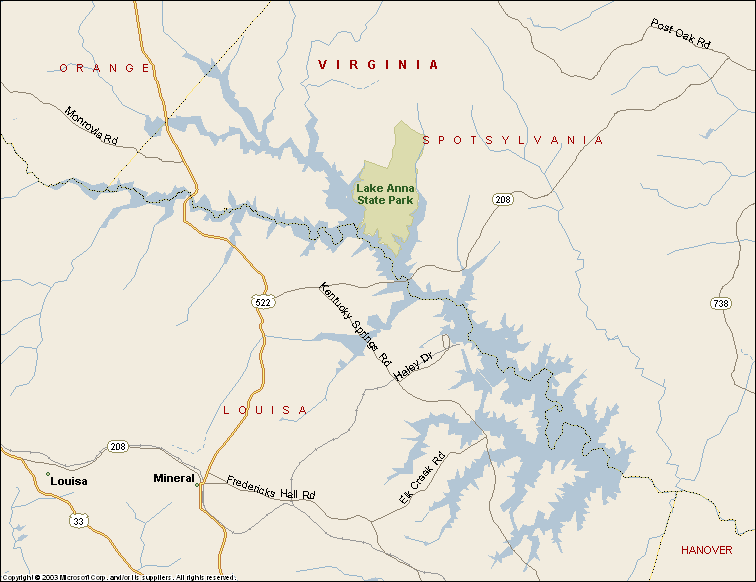
Lake Anna is a 9,600-acre impoundment located in Louisa, Orange, and Spotsylvania counties, owned by the Dominion Power Company. The impoundment was completed in 1972 and serves as cooling water for the North Anna Nuclear Power Station. Initial stockings began in 1972, with introductions of largemouth bass, bluegill, redear sunfish, and channel catfish. Subsequent stockings of channel catfish, largemouth bass (northern and southern strains), redear, striped bass, and walleye were made to improve and diversify the fishery. Blueback herring and threadfin shad were successfully introduced in the 1980’s to provide additional forage for pelagic (open-water) predators.
Annual stockings of striped bass and walleye are generally made to maintain the fishery. Prior to 1985, a 12-inch size limit was in effect for largemouth bass. Since that time, a 12 – 15 inch protected slot has been in effect to restructure the largemouth bass population. The current regulation allows harvest of fish less than 12 inches and larger than 15 inches. Fish between 12 and 15 inches must be released. Striped bass are currently managed under a 20-inch minimum size limit.
Lake Anna is a reasonable drive from both Northern Virginia and the Richmond area. Outdoorsman can access Anna at nine private marinas, several campgrounds, and at Lake Anna State Park. Reservoir accessibility creates heavy use by both anglers and boaters, especially during summer months. A 2000 creel survey indicated that fishing pressure was around 24 hours/acre. The most popular species fished for included largemouth bass (69 %), striped bass (15 %), and crappie (12 %). Crappie (70%) were harvested at the highest rate, followed by striped bass (29 %) and largemouth bass (1 %). Surprisingly, almost 99 % of all largemouth bass caught were released!
Hydrilla vertricillata, an exotic aquatic weed, became established into Lake Anna during the late 1980’s. Abundance increased from 96 acres in 1990 to 832 acres in 1994. Triploid (sterile) grass carp were stocked into Virginia Power’s Waste Heat Treatment Facility in 1994 to control Hydrilla, and Hydrilla abundance is now quite low in both impoundment’s.
Lake Anna Area Information Sources
Lake Anna Online
Lake Anna Va. Site
Lake Anna Maps
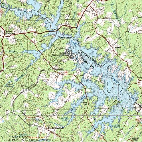
Topo Map
Outline Map
More Maps
Maps for Lake Anna can be purchased from the following map companies (Note click the name to go to their site):
GMCO Maps
Kingfisher Maps
Fishing Hot Spots
BC Fishing Maps
Lake Anna Articles
List of additional reading on Lake Anna fishing I have found.
Chesapeake Angler Magazine on Spring Striper Fishing on Lake Anna
VaBass website
Game and Fish website on Fall Stripers at Anna
Game and Fish website on Winter Stripers at Anna
Fishing Information
Largemouth bass, striped bass, and crappie are the main species of interest at Lake Anna. Opportunities also exist for anglers to catch bluegill, channel catfish, walleye, white perch, and yellow perch. This fishery is very diverse and offers something for every angler’s taste.
Largemouth Bass
Lake Anna is a top bass fishing destination for anglers residing in central and northern Virginia. This reservoir frequently is host to local and regional fishing tournaments, and for good reason; Anna consistently ranks in the top three statewide for numbers of citation largemouth bass. Intensive fishing pressure is the norm at Anna, but this reservoir maintains very high catch rates and good numbers of fish in the 4-6-pound range.
Routine population sampling conducted by fisheries biologists provides the Department with information pertaining to the status of the fishery. Comparisons can be made between electrofishing samples conducted during different years, which allows biologists to assess changes to the fishery. One index used by biologists is the CPE-P or “catch per effort of preferred fish”. The CPE-P for largemouth bass is the number of fish 15 inches or larger that are collected per hour of effort. Lake Anna, with a CPE-P of 19, ranked eighth in the district (out of 20 reservoirs recently surveyed) in 2003. This CPE-P was slightly above average but lower than record values observed during 2001, suggesting that bass size structure recently shifted downwards slightly. Overall, catch rate of bass was at a record high in 2003 thanks to above average catch of fingerlings and fish within the slot.
Heavy fishing pressure and boater use combined with abundant forage may make it difficult to consistently catch fish at Lake Anna. Patience is the key, and anglers willing to try different techniques and lures to match the prevailing conditions should find success. Largemouth bass typically are found in transition areas between different habitats, particularly around heavy cover and off points. Anglers should concentrate their efforts in these areas, fishing with a variety of lures such as plastic worms, jigs, spinner baits, or crankbaits. Anglers looking to get away from the crowds, especially the heavy boat traffic may consider fishing during winter and summer nights.
Striped Bass
The striped bass population is maintained by annual stocking. Stripers grow well in Lake Anna, at least for the first few years, and quickly attain the legal size of 20” in about 30 months. However, growth of older fish slows due to the lack of good striped bass habitat (cool, well oxygenated water) during summer and early fall months. However, an excellent fishery has developed within the capacity of available habitat. A major winter fishery has developed when stripers can be observed feeding near the surface. These fish can be caught with lures (e.g., sassy shads, redfins, bucktails) or live bait (gizzard shad or blueback herring, with the nod going to the latter if you can catch them). The outlook for striped bass is bright, as netting in winter 2003 indicated population density was above average with lots of 4- and 5-year-old fish.
Black Crappie
The size structure and growth of crappie in Lake Anna is good. Populations of crappie tend to be cyclical in nature – kind of a boom/bust situation. What this means to anglers is that the quality of fishing may vary from year to year. Anglers interested in pursuing this tasty fish should have no problem catching a mess of them at Anna. The key is to fish where the fish are. Sometime around mid March to early April, crappie move into shallows (5-6 feet or less) to spawn. Recent angler creel survey data shows that crappie numbers have been good in the Christopher Run area of the North Anna arm. Anglers should concentrate their efforts around structure such as fish attractors, brush piles, boat docks, or bridge pilings. Crappie can be successfully caught by a variety of methods ranging from small jigs, spinners, or flies fished with ultralight spinning gear, or anglers may desire more traditional tactics such as fishing small minnows with a cane pole and bobber. Remember that crappies are a schooling fish, and once a fish is caught, it is likely that several more will be caught within close proximity.
Bluegill
A fair bluegill population is available at Lake Anna; however, it would not be a recommended lake for this species. Bluegill populations are usually suppressed in large reservoirs with complex fish communities such as Lake Anna. Fair numbers of bluegill are found in the 5-6 inch range, which provides anglers some opportunity to fish for this delightful panfish. Bream fishing does not have to be complicated. Anglers may use live bait such as worms or crickets with hopes of enticing a strike. Some anglers prefer to use ultralight spinning gear or fly fishing gear to present small lures or flies. Pound for pound, there’s not a fish that fights any harder than a scrappy bluegill. Bream are easy to catch which makes them ideal for introducing young children to the sport of fishing. Best of all, if you’re at the lake and nothing else seems to be biting, you can normally count on catching a few bluegills.
Channel Catfish
Channel catfish were first introduced into Lake Anna in 1972, and since that time a naturally reproducing population has developed. Most catfish range from 14-20 inches and average 2-4 pounds. Many anglers pursue channel catfish during summer months when fishing success decreases for other species. Catfish anglers usually bottom fish using a slip-sinker-rig offering live bait (shiners, nightcrawlers), cut bait (herring, shrimp), or dough baits. Chicken livers are also an excellent choice here. A potential state record (and possible world record) channel catfish was caught and released by biologists in a gill net in December 2002 during a routine survey near Dike III. This monster was released and should still be swimming the depths of the old quarry near the dam. Anna also has a large population of white catfish as well as two species of bullheads.
Walleye
Many anglers target walleyes in the Pamunkey River Arm of Lake Anna from February – April. During this time of the year, fish are found along the red clay banks and drop-offs and may be very shallow even during the middle of the day. Walleye can be caught utilizing a variety of techniques. Some folks use medium action spinning gear to cast plastic grubs or crank baits, while others may troll lures or spinners. Many anglers still prefer to fish with live bait such as minnows, leeches, or nightcrawlers. During summer, many successful walleye anglers fish at night. One popular area is around the Rt. 208 bridge.
The walleye population in Lake Anna is maintained by annual stocking. A walleye study was recently completed on Lake Anna, which provided Department biologists with important information on the habits of walleye within this reservoir. Adjustments to the stocking program improved the fishery during the past several years, and catch rates of walleye in gill nets reached record levels in 2002 and 2003. Despite stockings throughout the reservoir, fish still are overwhelmingly found in the Pamunkey Creek arm in the vicinity of and above the “S curve”. Target Henry’s and Bennett’s Point in the upper Pamunkey and Rose Valley in the North Anna arm.
A special walleye section was published in the June 2001 issue of Virginia Wildlife , which included the findings of a recently completed research study at Lake Brittle and other state waters. Anglers looking to enjoy this unique fishery should obtain this handy reference from a local DGIF office to add to their fishing library.
White Perch
White perch are caught in good numbers during late fall and winter. Angler creel survey data collected by Department biologists has shown that November is the best month to catch white perch at Lake Anna. Nightcrawlers and bloodworms are effective baits for this small member of the striped bass family.